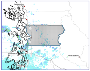
Snohomish-
Including the cities of Everett, Lynnwood, Marysville, and Edmonds
921 AM PST Wed Jan 5 2022
…FLOOD WATCH IN EFFECT FROM LATE TONIGHT THROUGH SATURDAY
AFTERNOON…
* WHAT…Flooding caused by rain and lowland snowmelt is possible, with an increased threat of landslides.
* WHERE…A portion of west central Washington, including the following county, Snohomish.
* WHEN…From late tonight through Saturday afternoon.
* IMPACTS…Excessive runoff may result in flooding of rivers, creeks, streams, and other low-lying and flood-prone locations. Melting lowland snow will contribute to the flood potential and to soil saturation and thus, increasing the threat of landslides.
* ADDITIONAL DETAILS…
– A period of precipitation from Wednesday evening through Friday will result in accumulations of water equivalent of 4 to 9 inches for the Cascades, and 1 to 3 inches in the lowlands, with locally higher amounts. The snow level will rise over western Washington resulting in a good portion of the precipitation falling as rain. Lowland snow over much of the area will also melt, contributing to saturated soil and storm runoff. The uncertainty with the rising snow level and the amount of lowland snowmelt makes the flood potential quite uncertain as to how much flooding there will be.
– http://www.weather.gov/safety/flood
PRECAUTIONARY/PREPAREDNESS ACTIONS…
You should monitor later forecasts and be alert for possible Flood Warnings. Those living in areas prone to flooding should be prepared to take action should flooding develop.


January 5, 2022
Everett